As of writing thing, the senior capstone project is effectively complete. In the past week, we have presented three posters at the SATT poster symposium, finished a department display case, have started organization of an intended publication, and have processed several hundred gigabytes of data that will be useful to further classes and research endeavors. In many ways, there is much to be completed here at Purdue that unfortunately I will not be able to (directly) continue with, but I know the program is being left in good hands with capable faculty and students. Being part of the inaugural class, I was initially nervous that the program would not be ready and put me at a disadvantage in the early days of my career. Now, four academic years after my initial lecture in the program, I have realized that I had nothing to worry about.
Graduating next week, I want to use this final post as predominately a reflection on the program, the great successes of its structure, and how it has changed how I envision UAS as a whole. While I may have one final additional post in the future to link in a future blog or website for my work in following years, this is the final sustenance post for this capstone.
Years in the Program
The program, if intentional or not, is really structured around a few main conceptional pillars.
1) UAS regulation, industrial knowledge, and trends
2) UAS engineering, construction, and repair
3) UAS manual and autonomous flight operations
4) UAS data collection, processing, and analysis
5) UAS applications
During my time in the UAS major, each of these pillars were explored in a variety of capacities at different times and to different capacities. While some of these sections were certainly weaker at different points in time, they are all now fundamental in the curriculum, or at least strong enough to where every graduate can address each of them professionally. It is in these pillars that I think the program is exceptionally unique, and where its value versus other UAS programs is founded. Like many other collegiate UAS programs, we are nested in a larger organization, Purdue Polytechnic, and more specifically the School of Aviation and Transportation Technology (SATT). However, unlike other programs, we have gathered the identity of UAS as a field. In most other institutions, the UAS program adopts the identity of their parent organization. It would be easy for us to take on the perspective of our aviation host organization exclusively, just as it is easy for other UAS programs to focus on an engineering centered curriculum if they are part of an engineering college, or a large military UAS curriculum if that is the industry the parent institution works with most. However, this single topic centered design is harmful to UAS students. UAS is truly, at least in its current state, a field of disruption. Where drones are valuable is in the conversation of expensive and slow tasks into a quick and cheaper alternative. UAS is literally the democratization of aviation to the point where not only is aviation oriented careers possible by individuals of lower economic status, but entire industries that could benefit from UAS can have access to the field.The broad approach to drone technology by our department allowed me to think broadly about UAS, and connect any aspect of the field to any other aspect. I learned to think critically about drone technology to the point where I learned to adjust the parameters of what has been done to be useful where drone have not been used before. This has allowed me to start the foundations of a research career both at Purdue (Figures 1-4) and at different institutions (figures 5-6).
 |
| Figure 1: In the field with Todd Horn, preparing a phantom 3 ADV UAS for forestry research. |
 |
| Figure 2: Launching an E-Bee UAV for agriculture research. |
 |
| Figure 3: Presenting my research on UAS use as a forestry survey tool for small forest plots at the Purdue Undergraduate Research Conference. |
 |
| Figure 4: An automatic motor testing stand designed and built by Ryan Ferguson and myself to identify efficiencies of sUAS motor/propeller combinations. |
 |
| Figure 5: Myself flying for a kelp forest research project with scientists at UCLA. |
 |
| Figure 6: Multispectral kelp forest data from the flight in figure 5. |
While I am choosing a research career, many of my fellow students are not. The strength of the program's approach is that any student can reasonably build expertise in a number of different fields. We have graduates becoming managers, engineers, scientists, pilots, and technicians. All of which, have skills that would make them candidates in the others. Truthfully, this is how UAS has to be approached, because a drone engineer needs to understand the needs of the data scientist who will utilize his system, or the technician who will use it in the field. Likewise, field operators need to understanding the engineering of their platform to correct issues in the field. A multidisciplinary approach is the only way to teach UAS, and this is what I feel Purdue UAS has done well.
The structure of the program has also been very accommodating to new learners. With an early emphasis on understanding systems, drone construction (Figure 7), advanced manufacturing techniques (Figure 8), and experimentation (Figure 9), students can grasp the foundations of the technology quickly.
 |
| Figure 7: A quadcopter design I created for a class in the earlier years of the program. |
 |
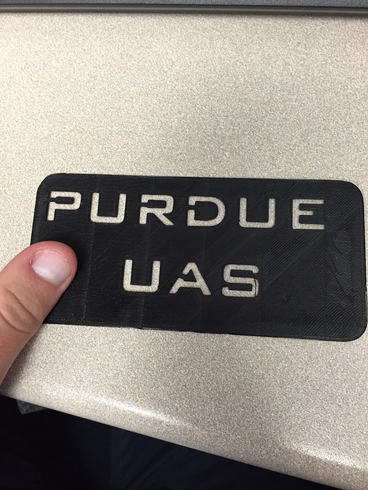
| Figure 8: A 3D printed phone case I made using techniques taught in early drone manufacturing and systems classes. |
 |
| Figure 9: Modified 3DR Solo UAS to act as an airborne radio repeater for search and rescue operations. Designed as a sophomore class. Contains 3D printed parts designed by myself and fellow students. |
After the courses structured towards designing and tinkering, we have courses meant to introduce us students to manual and autonomous drone operations. Sometimes with significant success (Figure 10) and sometimes with initial failures (figure 11). After the flight portions of the class, we had courses designed to introduce students to applications and UAS data, especially the course I now TA for, AT 319, which has had a significant redesign recently. Many of the data product skills learned in the class are present through the blogs of this page (Figure 12). Lastly, a series of capstones to combine all the individual skills we had learned. With this course structure, I feel I could perform successful at almost any career in the UAS industry.
 |
| Figure 11: Flight of a modified inspire 1 UAS. We added multispectral imaging capability to the aircraft in addition to its usual payload. |
 |
| Figure 12: A midair collision during a mutli-platform flight exercise early in the curriculum. |
 |
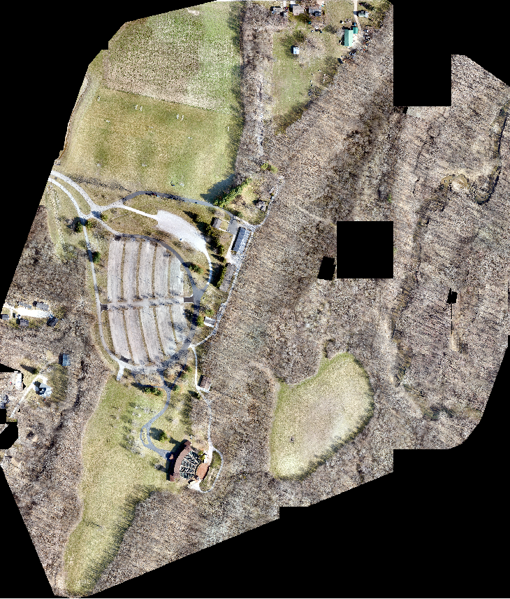
| Figure 13: A 70 ha orthorectified mosaic data-set of Tippecanoe County Amphitheater park. 1.3 cm/pixel. To see this image as a map with scale, see previous blog post. |
The structure and methods of the program has equipped me with the capability to become a successful scientific researcher. I have no doubt that the entirety of my skill-set gained through this program will aid me in my future endeavors. While I do not plan to be an engineer, I am certain my fundamental understanding of aeronautical science and understanding will help me in some form of emergency or go-no-go decision in the future. I am confident that somewhere, somehow, even tangential skills such as 3D printing will be useful in integrating a sensor or prototyping a design. I know that skills such as (but not limited to) GIS, remote sensing, crew resource management, safety management systems, flight operations, flight planning, aeronautical decision making, and aerospace regulation will be as critical to my success as my future skill-set in ecological science methodologies. I hope to stay close with my fellow students, not just for memory sake, but because I am certain our contrasting specialties will be useful together.
Final Flight
Briefly, I want to introduce the final flight and dataset we collected as a class. We flew our longest mission with the C-astral platform yet, at 68 minutes, and captured data for a 100 hectare area that was almost a kilometer away from our launch site. The large size of the platform allowed the aircraft to remain in view the entirety of the time. Today, I had finished the processing on the collected dataset of over 1600 images. At about 1 cm/pixel the following images contain subset screenshots of the Purdue Wildlife Area operated by Purdue FNR as taken from our dataset. Please enjoy the following images at your leisure. Boiler Up, Purdue Class of 2019.
 |
| Figure 14: Purdue Class of 2019 (few members not present). |
 |
| Figure 15: C-astral Bramor post landing. |
 |
| Figure 16: Subset screenshot image of the PWA. Shows drastic heterogeneity of the landscape. |
 |
| Figure 17: Subset screenshot of PWA ponds. Clear measurable quantities of surface algae. |


No comments:
Post a Comment