The Data Transfer Checklist and Issues with Drone Logbook
The primary and ongoing task of the week was to finish our final checklist before we can begin flight operations once the weather improves. This checklist is the data transfer checklist. Being far more descriptive than a traditional checklist, it is more like a step-by-step extended guide regarding how to properly transfer, save, and format data post-mission. Its purpose is to ensure that there can be a simple transition for data personnel to begin processing the data without confusion regarding where the data is, what the data is, and what should be done to it. In order to remain consistent with other checklists, the Drone Logbook interface was used to store the checklist.Working with Drone Logbook exposes some of the issues with the technology. First of all, the checklist can only be accessed by either reading it directly from the website, or by starting a flight on a mobile device. This is not necessarily an issue as long as we train flight crews to not conclude the flight until data has been stored. The other issue is the functional style of Drone Logbook's checklist creation interface. Essentially, when someone creates a new checklist, they are just creating an empty bin where steps can be created or moved into. While you can create each step in the active checklist (left of figure 1), it also populates the list of steps that have been created for all checklists (right of figure 1). This not only creates a clunky confusing interface, but it presents functionality issues. If someone accidentally moves over a step from the list on the right, it can significantly alter the order of steps that were in the right location. Because the app does not have a drag-and-drop feature, the arrow buttons must be used to move checklist steps, which is very time consuming and has potential for errors. Another issue with this format is that if I wanted to move a step into the right list (figure 1) that effectively acts as storage, it would be incredibly difficult to find the exact same step because it would be populated somewhere among the massive list of steps containing every step from every checklist we have generated. Drone logbook needs to include a function to bin checklist items in some sort of folder structure that can be filtered out or the feature could become unusable in the long run. Drone operations are simply too complicated with too much variation between ground equipment, vehicles, and residual steps for the Drone Logbook approach to checklists.
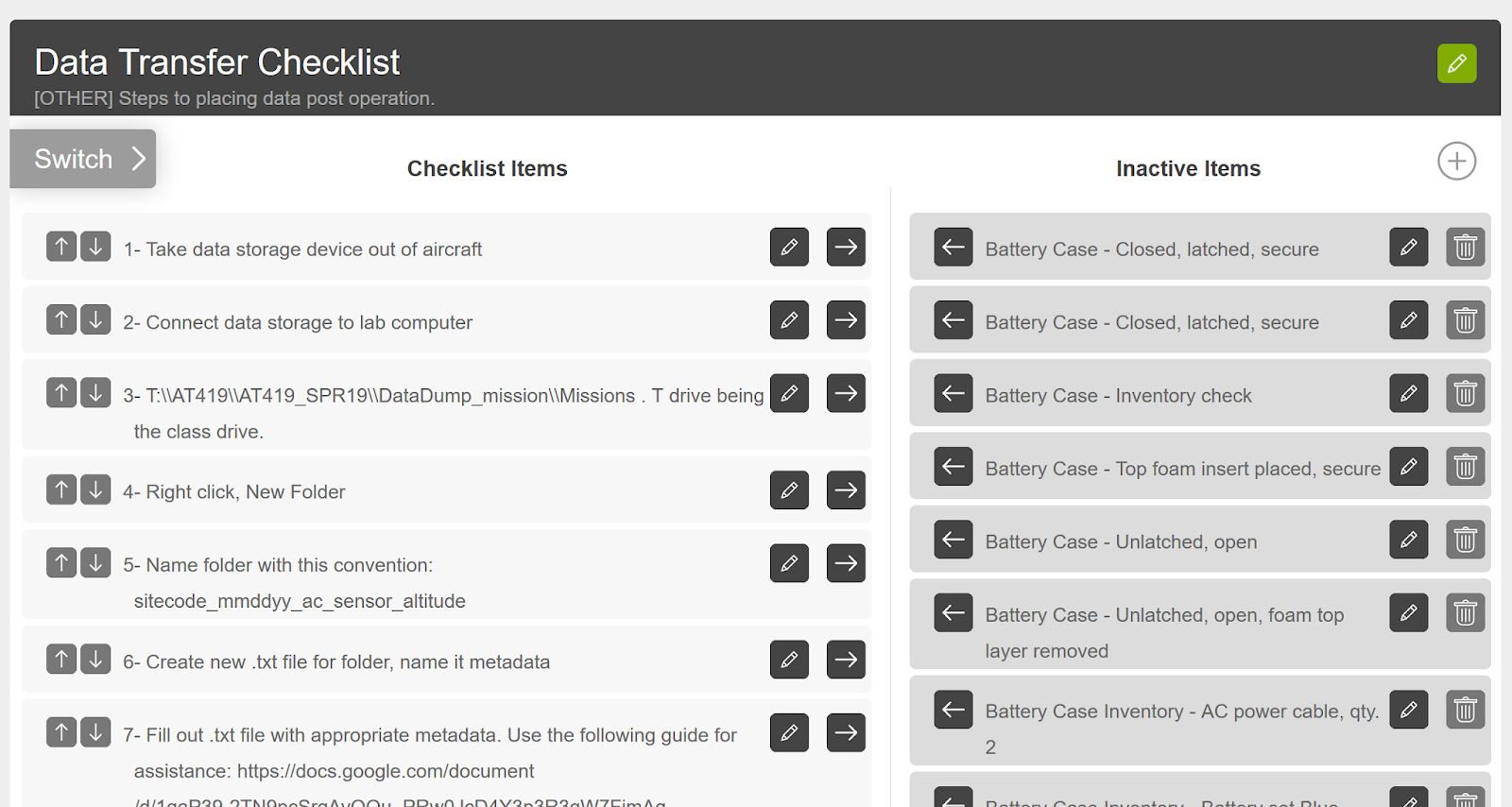 | ||||||
| Figure 1: Subset of Data Transfer Checklist on Drone Logbook. The left side is a correctly populated list of checklist items. The right is the non-filterable list of inactive items. |
SATT Poster Symposium
An announcement for our school's poster symposium was made this week, and we decided that we would enter a series of posters. While the complete list of posters seems inconclusive at the moment, what seems certain is I will be leading the poster regarding the specific type of application our capstone is centered on with Krysta. I will also be conducting preliminary data-analysis as part of the poster, in particular comparing accuracy of different methodologies, which will be useful throughout the rest of the project. Krysta and I will be comparing the accuracy of flood extent delineation between two different drone remote sensing methods. The first will be a manual geospatial video technique, and the second will be an autonomous multispectral photogrammetric approach. Accuracy will be determined by comparing where flood water can be delineated in each method to ground control measurements taken at the extent of flood waters by ground crews. I suspect that the geospatial video technique will be less accurate, but be able to cover a larger area in far less time than the autonomous technique.The basic methodology needs to be designed further, as well as various aspects of the poster itself. Most of this will happen next week (week of 2/18). Despite the lack of various details at the moment, I have generated a basic timeline that will be used to gauge progress and ensure all mandatory steps are completed (Figure 2).
 |
| Figure 2: Timeline for SATT Poster Creation. |
This upcoming week will largely be structured around flushing out the details for the poster. Krysta and I will meet Wednesday to discuss what type of literature review she has completed, what we can take from that, and what additional details we will need. I assume that some additional literature will need to be collected regarding remote sensing of water, the need for flood analysis by air (by drone), and any other specific UAV studies that may have been conducted on this topic.
No comments:
Post a Comment